GIS meets EMS: How a map could save your life
Departmental collaborations are an everyday occurrence at the City of Auburn. This one upped the ante, improving safety at Auburn's state park.
Today, most of us could navigate practically anywhere by entering an address into our phone.
But what if you don’t have an address? And what if you’re looking for someone who isn’t quite sure where they are? And what if they’re in danger?
In fall 2022, the City of Auburn’s Emergency Communications team — tasked with getting police, fire and ambulance services to Auburn residents in an emergency — had to answer these questions in real time.
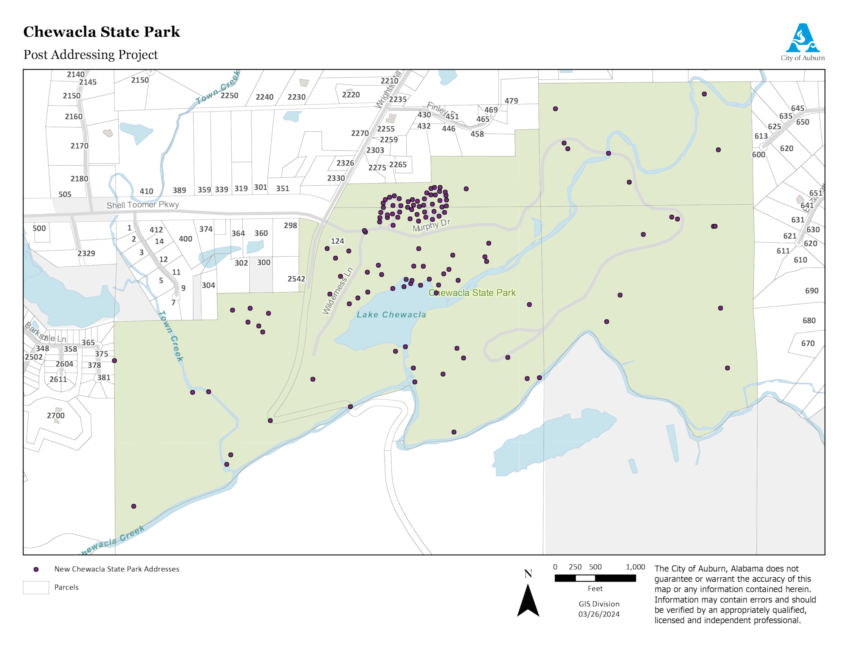
All 696 acres of Chewacla State Park has one address: 124 Shell Toomer Parkway in Auburn. When Communications Supervisor Trent Mitchell received a medical rescue call from someone hiking the park’s nearly 30 miles of trails, he had to be creative to get emergency responders more information than the location of the park entrance.
The caller reported they were “at the waterfall,” and the park rangers station said the caller was at the overlook. The 911 caller plotting system showed the caller on a trail in a different area of the park.
While the plotting system will sometimes show a large area in which the caller might be, this time, Trent said they got lucky — a tight circle pinpointed the caller’s location.
Instead of using traditional coordinates to let Auburn Fire know where the caller was, Trent used what3words, a system designed to identify any location within about 10 feet by putting a grid over the world and attaching three unique words to each box on the grid. Users can easily identify any location using the words in place of traditional latitude/longitude coordinates.
It took 17 minutes for emergency personnel to get to the caller, who was found near the overflow pipe that runs from the quarry into the state park (not at either of the park’s two waterfalls). They then began the challenging task of getting the caller out of the park, and the caller was life-flighted to a nearby hospital to receive the treatment they needed.
Auburn Fire and Emergency Communications met after the incident to review what went well and what could be improved. While communications received high praise for their work during the call, Trent saw gaps in the process. He regularly worked with the City’s GIS team to get new homes and other missing locations plotted on the City’s mapping system, and he wondered if they could do the same at Chewacla.
GIS had discussed a project to add sub addresses to golf courses throughout Auburn to provide more specific location points within the courses, but the project had been just an idea for some time. When Trent approached with a need at the state park, Deputy Chief Information Officer Christopher Graff saw “an opportunity to dig into the project.”
Christopher brought key stakeholders together, including representatives from Auburn Public Safety, Chewacla State Park and Central Alabama Mountain Pedalers (CAMP) — a volunteer group that helped construct and frequently uses the trails at the park.
"This was an opportunity to work together so we didn’t end up with something that left out pieces of the puzzle,” Christopher said.
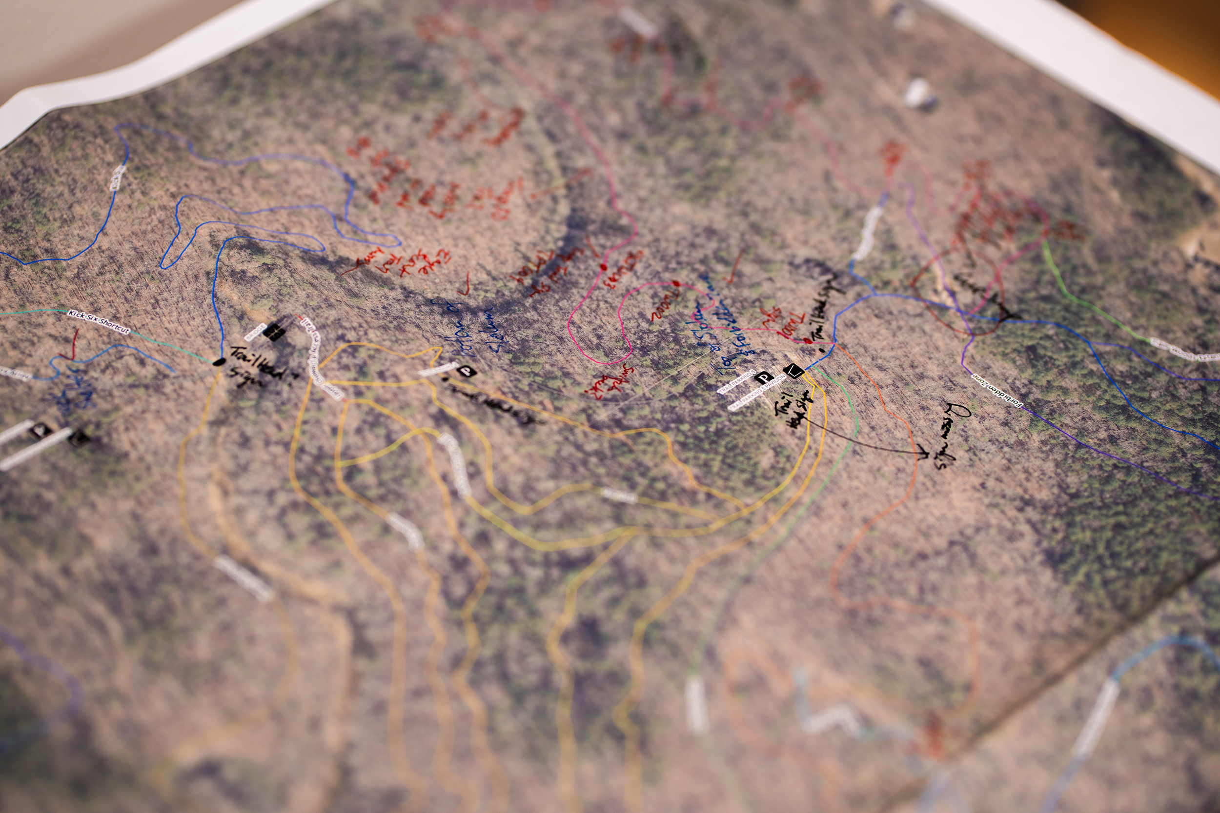
The group started by gathering around an aerial image of the park and identifying key points. They talked through cabin and campground numbers along with street and loop names to ensure they had consistent, agreed upon identifiers for each one. They took note of the locations from which most people call park rangers either for help or with an injury, such as jumps for mountain biking along the trails.
After the meeting, GIS Technician Jennifer McKibben walked many of the trails to get a better understanding of the topography and to scope out potential map point placements. GIS then got to work adding those points to the City’s existing mapping system and updating an old CAMP trail map to account for additions, trail name changes and trails that are no longer maintained.
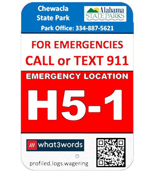
Along with the mapping piece of the project, local Eagle Scout Nathan King from Troup 12 in Auburn was already working with the park and CAMP to update trail signage. Communications Administrator Charlsie Little collaborated with Nathan and the park to determine what should go on the signs and where they should be placed. They decided to include multiple identifiers on each sign, including its what3words designation and a three-character combination they developed to identify where the sign was located within a grid map of the park. Twenty-two new signs were placed along the trails.
Another critical component of the project was determining the quickest route to reach someone within the park. While the main park entrance may be the fastest way to reach someone at the lake, it may be better to use an emergency access entrance in adjacent neighborhoods to reach someone on an isolated trail.
In the end, the team’s efforts resulted in more than 120 new sub-address points within Chewacla State Park. Now, rather than communications spending time trying to figure out the best way to describe a caller’s location, there are over 120 points to which they can quickly direct emergency responders. Auburn Fire has also incorporated the new map points and the updated trail map into its pre fire planning.
“During that training, they’re learning those points of interest, those addresses, those trails and how to access all of them,” Christopher said. “All of this data allows them to stay ahead of the curve.”
The project is already paying off. This April, a caller reporting a medical emergency used one of the new signs to convey their location. Auburn Fire was able to reach the caller in 10 minutes — seven minutes faster than a 2021 medical call in the same area.
The team has plans to help improve response times by expanding the project to other areas of town, including City parks, golf courses, the Kreher Preserve and Nature Center and Jordan-Hare Stadium. By doing so, first responders will not only be able to locate 911 callers faster, but Public Safety will also be able to use call data to identify problem areas within a park or facility that could be mitigated.
You can explore the newly added points at Chewacla State Park by viewing the COA Map at auburnalabama.org/maps. You can also find a location’s what3words designation via the what3words app or by visiting what3words.com.